Back بولنغ غرين (ميزوري) Arabic بولنج جرين ARZ بولینق قرین، میزوری AZB Bowling Green (Missouri) Catalan Боулинг-Грин (Миссури) CE Bowling Green (kapital sa kondado sa Tinipong Bansa, Missouri) CEB Bowling Green, Missouri Welsh Bowling Green (Missouri) German Bowling Green (Misuri) Spanish Bowling Green (Missouri) Basque
Bowling Green, Missouri | |
|---|---|
| City of Bowling Green | |
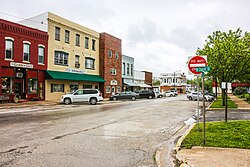
 Bowling Green, Missouri in 2015 | |
 Location of Bowling Green, Missouri | |
| Coordinates: 39°20′41″N 92°12′11″W / 39.34472°N 92.20306°W | |
| Country | United States |
| State | Missouri |
| County | Pike |
| Area | |
| • Total | 2.70 sq mi (7.00 km2) |
| • Land | 2.69 sq mi (6.97 km2) |
| • Water | 0.01 sq mi (0.04 km2) |
| Elevation | 892 ft (272 m) |
| Population (2020) | |
| • Total | 4,195 |
| • Density | 1,560.06/sq mi (602.28/km2) |
| Time zone | UTC-6 (Central (CST)) |
| • Summer (DST) | UTC-5 (CDT) |
| ZIP code | 63334 |
| Area code | 573 |
| FIPS code | 29-07660[3] |
| GNIS feature ID | 2394228[2] |
| U.S. Routes | |
| Website | http://www.bowlinggreen-mo.gov/ |
Bowling Green is a city and the county seat of Pike County, Missouri, United States. The population was 5,334 at the 2010 census. [4]
- ^ "ArcGIS REST Services Directory". United States Census Bureau. Retrieved August 28, 2022.
- ^ a b U.S. Geological Survey Geographic Names Information System: Bowling Green, Missouri
- ^ "U.S. Census website". United States Census Bureau. Retrieved January 31, 2008.
- ^ "Find a County". National Association of Counties. Archived from the original on May 31, 2011. Retrieved June 7, 2011.